
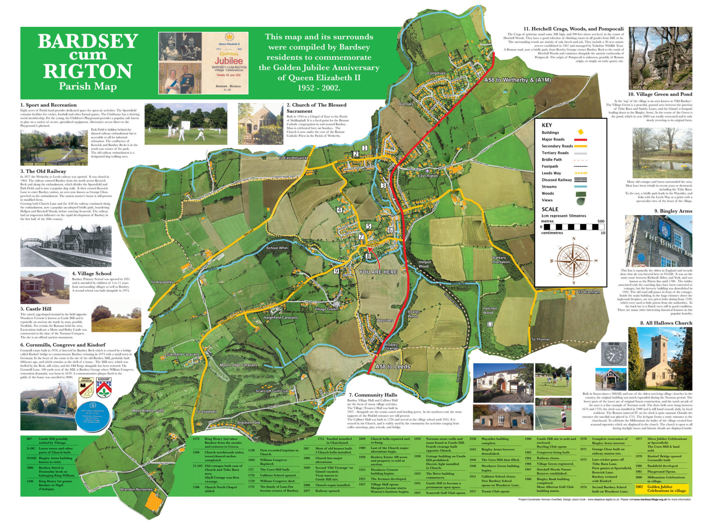
Walks in Bardsey by Sue Cairns
Walk 1 (1 hr)
From Tithe Barn Lane where you can park beside the telephone box, head up Blackmoor Lane passing the Caravan site and 2 houses on your left and then over a stile into field on your left. Across the edge of the field, go over another stile onto an enclosed path, continuing until another stile taking you into woods behind Scarcroft Golf Club. Another stile takes you along the edge of the field with the club house on your right and out onto Syke Lane Scarcroft.
Turn left past houses; just after you pass a turning to your right you turn left along a drive and into woods on a footpath running parallel with the A 58. On reaching Wayside Mount, turn left up the unmade road all the way to a gate which takes you to open fields. Turn sharp left following the path to the duck pond and then up Tithe Barn Lane back to your car.
An alternative is to park in the village by the Church and go through the church yard and out of the gate and up the field directly behind the Church to the top where you rejoin the above walk.
Walk 2 (1 hr 15 mins)
Starting from the Church, walk along Church Lane towards the 458, cross the road carefully and scramble up the bank into woods; then continue along the old railway track until you drop onto another path where the old bridge used to be; then turn right following a well defined track on the edge of open fields until you come back to the 458. Again crossing with care go up Wayside Mount, through the gate, and then instead of turning left to the duck pond go straight on down the hill back to the Church.
To make a longer walk, when you get to the right turn where the bridge used to be, continue along the railway track coming into woods and then cross over an old bridge and immediately scramble down the embankment turning immediately left. Continue along past the old mill race and towards some houses. Here you will find a high stone stile; turn right over it along the field and across a little wooden bridge. Turn left into woods passing the trout farm on your left. Come out of the woods and turn right, climbing up the edge of a field and then down rejoining the original path just before the A58.
Walk 3 (1 hr 30 mins)
Start from the big trees on the Bramham Road at Wothersome. Go straight along the well used farm track and when reaching the woods take the left track dropping down to a junction; for a shorter walk, turn right here. However we take the left wide path alongside Bramham Lake. At the top of the lake turn right across the lake side and up to the back entrance to Bramham Park. Do not go out onto the road but go right again, following the well defined walk through the woods although the path does narrow a bit. Eventually you drop down to a ford. Wellies or good shoes are essential to cross the ford. Then scramble up and this is where the shorter walk rejoins us. Go straight up the field coming out on Dog Kennel Lane. Do not go down the lane but turn right straight across open fields towards the woods and back to the farm lane you started on.
Walk 4 Hetchell Woods (40 mins)
Parking either on the pull- in on the A58 or in Cornmill Lane, go up onto the railway track. However take the left fork through some woods and along an enclosed path at the bottom of the field. Continue with the beck on your right until you enter Hetchell Woods over a stile. Continue straight on until you come to the stepping stones and footbridge. Cross over them up the field and turn right onto the railway track and back to your car. Alternatively when entering the woods you can turn left and climb up turning right at the top across the Crags and then drop down to the stepping stones/bridge.
Walk 5 (1 hr)
As above until you get to the stepping stones and then continue straight on through a gate and over a stile into “Pompocali” (a reputed Roman campsite). Climb up for some lovely views then walk along the top dropping back down to the beck, through the old Mill and along an enclosed path. Over the stile the old bridge is in front of you. Scramble up the bank on the left and back onto the railway track turning right to go back and rejoin the route towards Bardsey.
To reach another entrance to Hetchell Woods cross the A58 in your car go up Mill Lane, right along Holme Farm Lane and then continue straight on along Milner Lane and you can park along on the right.
Walk 6 (1 hr)
Parking at the top entrance to Hetchell Woods, cross the road and go on a well defined path across the fields to Stubbing Moor (Wothersome). Continue on this wide track on the edge of the woods and when you get to the junction turn sharp right. Across the field edge to Dog Kennel Lane. Here turn right down the lane all the way to Milner Lane. Turn right along the road back to your car.
All the walks are dog friendly but remember that it is your responsibility to clear up after your dog, and control him if there is livestock about. All the footpaths and many others are to be found on Ordnance Survey Pathfinder 672 Harewood.
Once you have found the Railway track and Hetchell woods you can vary your walk daily. The timing of the walks is approximate but if you have any problems with them or in training your dogs, I will be happy to try and help.
Other walks
The OpenStreetMap service is a useful reference for public rights of way and permissive paths.
The following link will open a window focussed on the centre of our village.
Councillor Flockton also organises ‘Parish Walks’ usually twice a year.
Information on these will be placed on our events page.